|
The Myth of Two Central Viewing Points
By Mary E. Gage and James E. Gage
Previous researchers have argued that lunar, solar, and stellar astronomical alignments were viewed from two central viewing points. Joanne Lambert has summarized their theories in America’s Stonehenge: An Interpretative Guide as follows:
The area beneath this platform was excavated by Mr. Goodwin while he was looking for the quarry site of `Sacrificial Table’. In doing so he destroyed the ruins of two stone and dirt mounds which could have been used as central viewing points. Reference to these can be found in Mr. Goodwin’s book, The Ruins of Great Ireland in New England. Although he makes no mention of them in the text, it is clear from the sketch on page 61 that two beehive mounds did, in fact, stand at that location during the Goodwin occupation. (Lambert 1996, 44)
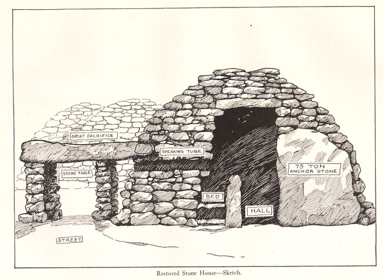
The theory of the two central viewing points for the astronomical alignments has rested upon the evidence cited in the above quotation. The artist sketch (fig.1) on page 61 of Goodwin’s book does indeed show two beehive like structures north of the oracle chamber. However, the statement “he makes no mention of them in the text” is incorrect. Goodwin discusses the sketch in detail on page 60:
Originally we think the main room of the Y cavern [oracle chamber] instead of a present length of 27’ was nearly 20 odd feet longer, ending up in the two huts we dug out of the north end of the mound. We believe that the two great glacial corner stones were there in situ when the master builder adapted them to anchor this building on the sloping bed rock. We present Professor Fagan’s graphic drawing of this situation from my suggested theory covering the master builder plan. (Goodwin 1946, 60)
The closest of the two viewing points is 40 feet away from the end of oracle chamber, 20 feet further than the maximum extent of the “two huts” Goodwin states. One or both of the “huts” referred to by Goodwin in all probability refer to the current enclosure on the north side of grooved stone. Goodwin clearly indicates that the sketch on page 61 is an artist rendering of his “suggested theory covering the master builder plan.” A review of the drawing itself, shows a number major mistakes which is consistent with it being an artist rendering of a theory rather than a detailed archaeological drawing. The ledge is shown as perfectly flat, when in fact it slopes at a moderate rate. The sketch shows a half height wall between the “bed” and main corridor, when in fact the wall extends to the ceiling. The “corner stone” is shown as three times as high as it really is.
Based upon Goodwin’s statement concerning the page 61 sketch and physical measurement he gave, it is concluded that there is no archaeological or historical evidence to support the theory of two central viewing points.
Rethinking the Alignments
The discovery of a carved drain in the bedrock 30 feet from the summer solstice sunrise stone has provided a new clue to how the alignments functioned. The drain is roughly chipped out and measures approximately 14 inches in length. The drain is located in line with the solstice alignment. Field observations on the summer solstice have confirmed that a person situated at the drain can accurately witness the disk of the sun rising over the lower right hand end of the slant on the standing stone.
The other alignments, specifically the summer solstice sunset, winter solstice sunset, and equinox sunrise, were most likely viewed from a position 30 to 60 feet from each standing stone. Field observations indicate the location of 30 to 60 feet from each standing stone was the most practical viewing location. At that distance, the alignment can be viewed with a high level of accuracy. The crowds of visitors who attend the solar alignments events have discovered this practical solution for themselves. 90% or more of the visitors ultimately congregate during the event at a distance from 30 to 100 feet from the standing stone. Distances greater than this prove to be completely unsatisfactory for viewing purposes.
 |
Fig. 1 - Professor Fagan’s sketch based upon William Goodwins’ “suggested theory covering the master builder plan.” The two “beehive huts” shown in background of the illustration are the source for the Central Viewing Platform Theory. (From William Goodwin’s Ruins of Greater Ireland in New England, pp. 61.)
Fig. 2 - This photo shows the “north end of the mound” which Goodwin’s crew excavated and Goodwin believed was the foundation of two “huts”. Modern archaeological analysis suggests that this area was an extension of the ceremonial area around the grooved stone. The two recessed areas which are probably the source of Goodwin’s “hut” idea are actually two recessed niches. The niches were most likely used to store ceremonial objects.
Fig. 3 - Summer Solstice Sunrise Alignment. Carved drain in foreground & alignment standing stone in background.
Scale is in inches.
Fig. 4 - Close up of carved drain feature. Scales in inches.
|
